K-State Research and Extension Agronomy eUpdate:
Update on Drought Conditions in Kansas - November 13, 2020
*This was taken directly from the KSRE Agronomy eUpdate - November 13th, 2020 Issue 827.
For the week ending November 10, 2020, statewide precipitation averaged 0.34 inches, 87 percent of normal. Again, the significant precipitation was confined to a small part of Kansas, the North Central region (Figure 1). The greatest precipitation reported for the week was 1.60 inches at Plainville 4WNW, Rooks County, on the 10th. The North Central Division was the focal point for the highest precipitation in the state with an average of 0.75 inches, 227% of normal (Figure 2). The driest climate division was the Northwest with an average precipitation of 0.05 inches, 23% of normal.
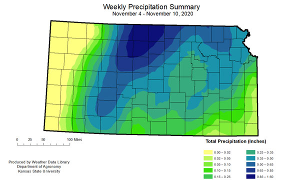
Figure 1. Total precipitation (inches) recorded for the week of November 4 – November 10, 2020. Map by the Kansas Weather Data Library.
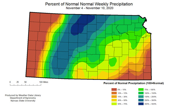
Figure 2. Percent of normal precipitation for the week of November 4 – November 10, 2020. Values less than 100 indicate below-normal amounts. Map by the Kansas Weather Data Library.
The week mostly consisted of much warmer-than-normal temperatures. Although, the week did finish on an average to slightly below normal note. With a 75 oF temperature swing during the period, the highest reading was 89 oF reported at Tribune 14N, Greeley County, on the 5th. The coldest temperature reported was 14 oF at Colby 1S, on the 9th. The state temperature averaged 59.0 oF for the week, 12.6 degrees warmer than normal (Figure 3). The North Central Division was the warmest with an average of 59.3 oF, 14.1 degrees warmer than normal. The South Central Division was the coolest at 58.9 oF, 10.6 degrees warmer than normal.
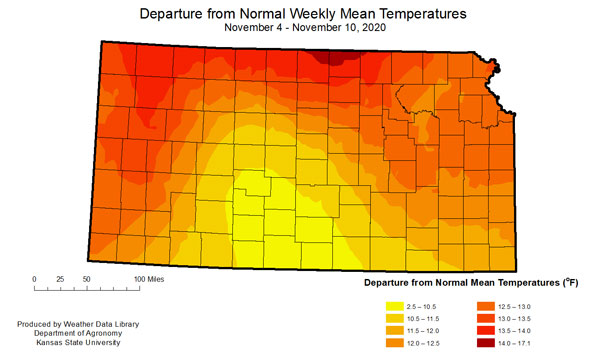
Figure 3. Departure from normal weekly mean temperatures for week of November 4 – November 10, 2020.
While the precipitation and cooler temperatures to end the week were quite noticeable, the previous warmer than normal temperatures and breezy winds offset much of that benefit. As a result, there was no change in the Drought Monitor with nearly 12% of the state in “Severe” or worse drought (Figure 4 and Figure 5). Despite no changes, the gusty winds (which did result in several large fires) and warmer temperatures led to increased moisture demands across the north/northwest part of the state during the period (Figure 6).
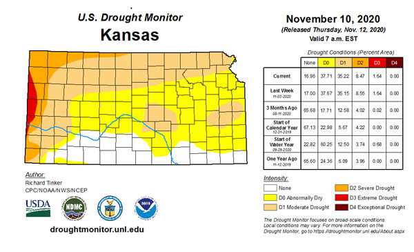
Figure 4. Current weekly drought status (U.S. Drought Monitor)
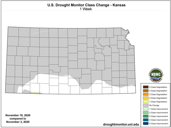
Figure 5. Change in weekly drought status (U.S. Drought Monitor).
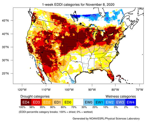
Figure 6. Evaporative Drought Demand Index factoring evaporative demand in respect to wind and moisture availability (NOAA, https://psl.noaa.gov/eddi/).
In the upcoming week, moisture will again be varied (Figure 7), with no precipitation expected in the west and central parts of the state. Some precipitation is expected in the far southeast, but will likely still be below normal (weekly average statewide precipitation for early November is 0.3 inches in the west to 0.8 inches east). A big change in the weather is possible beyond next week with a chance of above normal precipitation (Figure 8). However, temperatures are still forecasted to remain above normal. As we move later into November, average precipitation across the west continues to decrease, while remaining steady in the east. Outlooks for the entire month of November favor above normal temperatures and below normal precipitation statewide (Figure 9).
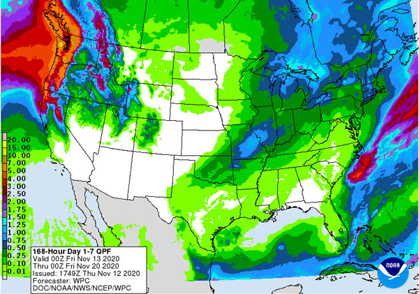
Figure 7. Quantitative Precipitation Forecast for week ending 10/15/2020 (Weather Prediction Center)
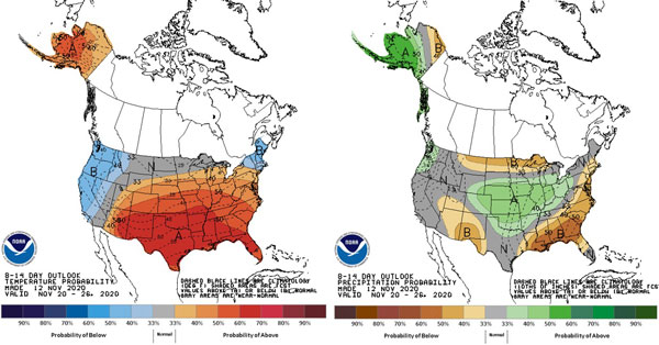
Figure 8. 8-14 day temperature and precipitation probability outlooks for Nov 20-26 (Climate Prediction Center).

Figure 9. Temperature and Precipitation Outlook for November 2020 (Climate Prediction Center)
Highlights
- North Central Division received the most precipitation.
- Much warmer than normal temperatures statewide.
- No change in US Drought monitor for Kansas.
- The precipitation outlook for the week ending 20-Nov is dry for most of the state.
Mary Knapp, Assistant State Climatologist
mknapp@ksu.edu
Christopher “Chip” Redmond, Kansas Mesonet Manager
christopherredmond@k-state.edu
*This was taken directly from the KSRE Agronomy eUpdate - November 13th, 2020 Issue 827.
KP
